Conceptual Model
A Bow Echo signature can be used as one of many signatures pointing towards thunderstorm severity. The presence of a persistent Bow Echo signature should be associated with the presence of a strong Rear Inflow Jet (RIJ) which, if it descends to the surface, is likely to be associated with damaging winds.
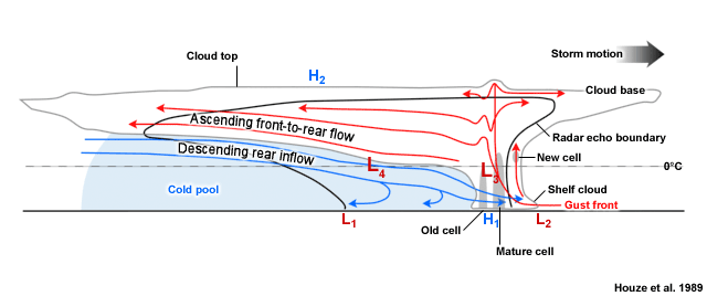
RIJs are formed starting with a linear convective mode with warm air ascending toward the rear of the line into the anvil via leading edge updrafts (see figure below). Latent heat is released from this rising front to rear airstream forming a hydrostatic low beneath the anvil but above the cold pool. The cold pool marks a hydrostatically induced mesoscale high. Air flows laterally from both the rear and front of the line, into the low. The presence of a front-to-rear horizontal mesoscale pressure gradient above the system cold pool contributes to the rear-to-front acceleration of air parcels into the low near the leading edge of the system. Diabatic cooling of this rear inflow jet under the stratiform rain canopy contributes to its descent as it approaches the front of the system.

Schematic of a mature squall line (also representative of the central section of a Bow Echo) with a trailing stratiform precipitation region. The thick line indicates the approximate system outline on radar, the light scalloped line the approximate visual extent of the clouds. Stippled and solid fill areas mark regions of higher radar reflectivities.
This conceptual vertical cross-section of a trailing stratiform Mesoscale Convective System (MCS) is adapted from Houze et al (1989). More details can be found in MCS Storm Conceptual Models, Definition, Fig. 4.
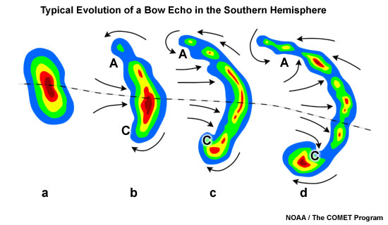
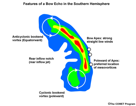
Alongside the RIJ, Bow Echoes are characterised by the existence of cyclonic (poleward) and anticyclonic (equatorward) bookend vortices. In longer-lived Bow Echoes, the Coriolis force eventually favours the stronger development of the poleward vortex. The bow's apex is a preferred region for damaging surface winds, but small-scale mesovortices at the leading edge of the line can cause localised damage, in particular towards the poleward side of the apex.

Typical evolution of a thunderstorm radar echo (a) in to a Bow Echo (b, c) and into a comma echo (d). Dashed line indicates axis of greatest potential for downbursts. Arrows indicate wind flow relative to the storm. Note regions of cyclonic rotation (C) and anticyclonic rotation (A); both regions, especially C, are capable of supporting tornado development in some cases.

Schematic of a Bow Echo in the southern hemisphere. Reflectivity contours are shown, with the green fill colour denoting reflectivity values in the 30s (dBZ), and red colours in the 50s (dBZ). The apex region along the leading edge of the Bow Echo is often an area of damaging surface winds. The northern and southern ends of the Bow Echo are usually chracterised by bookend vortices. Damaging mesovortices, if they occur, are preferentially found along the leading edge of the Bow Echo, poleward of the apex location.
There is a noteworthy alternative viewpoint explaining the kinematic and dynamic properties of Bow Echoes: Weisman (1992) conceptualised the formation of the RIJ through the interaction of horizontal vorticity centres of opposite signs near the back of the stratiform rain shield and system cold pool.
Bow Echoes can either be an entity in itself or a smaller segment of a squall line. The bowed segment develops due to the potentially strong Rear Inflow Jet contributing significantly to a forward surge of the system outflow and associated bowing of the leading convective line.
Bow Echoes and strong Rear Inflow Jets are most likely to produce damaging winds, a criterion used to define a severe thunderstorm in Australia.
Bow Echoes are mostly made up of ordinary, non-rotating or weakly rotating cells, but they can contain supercells. Such embedded supercells are not as long-lived as more isolated supercells, as their inflow tends to be disrupted by other nearby cells within the line. Supercells tend to favour the ends of the line for development due to better access to unmodified low-level inflow. If a supercell is detected within a Bow Echo, an increased potential exists for all four severe convective hazards occurring: damaging or destructive winds, large or giant hail, heavy rainfall resulting in flash flooding
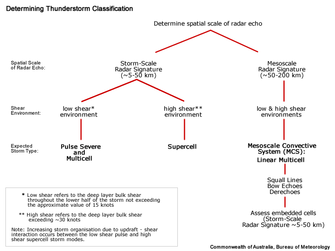
Determining Thunderstorm Classification
A significant Bow Echo with a strong Rear Inflow Jet is only associated with one type of thunderstorm classification: the Mesoscale Convective System (MCS).

See Mesoscale Convective System (MCS) for more information.
