Detection
This signature is based on organisation on the mesoscale. A Bow Echo is a type of linear multicell characterised as a bow-shaped (or concave-shaped), 20-120 km line of convective cells. Bow Echoes can be either in the form of an isolated line or as a bowing segment within a meso-convective system (e.g., a squall line).
Use the radio buttons or click the image to switch between reflectivity and velocity imagery:
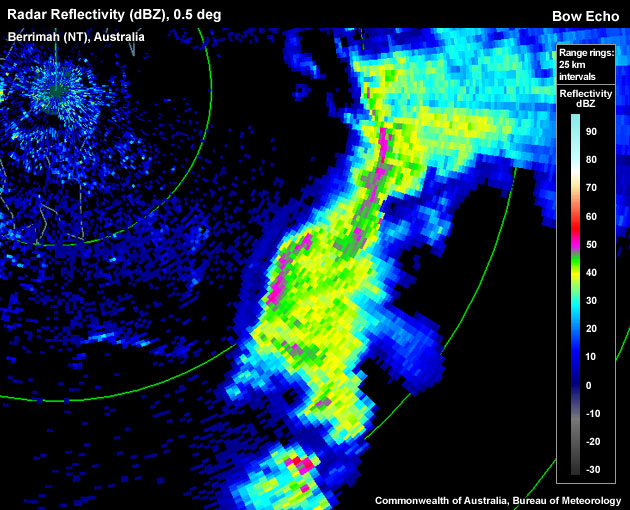
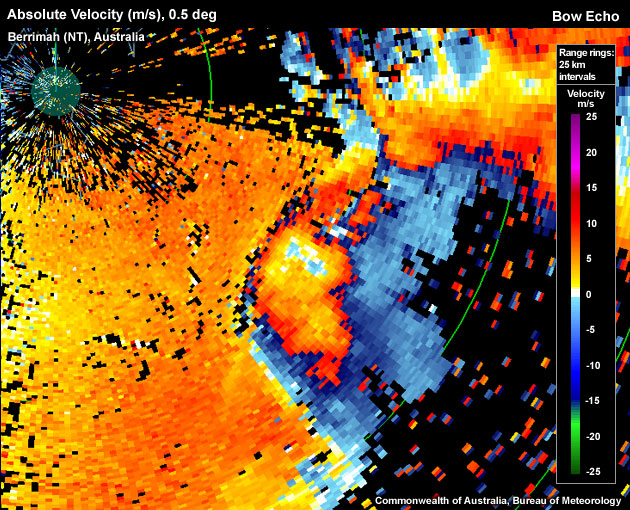
Bow Echo approaching Darwin (Australia) from the southeast; a gust front is apparent just ahead of the bow, and a Rear Inflow Notch (RIN) behind the apex of the bow.
One of the recognisable features of a Bow Echo is a Rear Inflow Notch (RIN). A RIN is a channel of weak reflectivties located well behind the core of the bow and it can signify the location of a strong Rear Inflow Jet (RIJ). A RIN is an especially useful feature for forecasters who have no access to Doppler data.
A RIJ is a velocity signature commonly found with a Bow Echo. A RIJ is an elevated jet accelerating (strictly, in a storm-relative frame of reference) from the rear to the front edge of the line of convective cells while descending towards the surface (and reaching it on occasion).
To determine if the signature you are seeing is a Bow Echo with a strong Rear Inflow Jet use the following criteria.
Reflectivity: PPI/Plan
- View using one of the lowest elevations; look for a continuous or broken up line of convective cells.
- Is the line of cells bowed in shape or are there any bowed 20-120 km long segments along the line? If so, a Bow Echo may be present.
- Supporting evidence for the identification of mesoscale convection as a Bow Echo is provided by the rear-inflow notch (RIN): on the “back” side of the bowing line (“back” with regards to the system's motion vector) a patch of weaker reflectivity might be apparent (the stratiform rain shield). Is there a notch of low or no reflectivity returns on the back side of that patch?
Velocity: PPI/Plan View
Here we are looking for a strong RIJ to provide additional support for the identification of a Bow Echo signature.
- In the vicinity of the bow's apex and the RIN (if present), look for a local maximum of velocity just behind the main line of convection. The velocity should decrease the further back you go from the leading edge of the line. Note: depending on the radar's Nyquits velocity the RIJ might be aliased in the velocity channel.
- Is the velocity maximum observed reaching or exceeding 48 knots? If so, a strong RIJ is present (damaging winds that have the potential of reaching the surface).
Velocity: RHI/Cross Section
An alternative view of the strong RIJ.
- Choose a cross section perpendicular to the line of convection, through the apex of the bowing segment.
- Is there evidence of a strong RIJ sloping down from rear to the front of the line of convection? If so, a strong RIJ is present.
Potential Difficulties in Detection
Radar sampling:
- Erroneous data, especially affects velocity data – Confidence in pixels is lowered.
- Resolution of the velocity data for the radar–Low radar resolution generally averages out extreme values.
- Resolution degradation as range increases – Radar sampling degrades as averaging becomes more enhanced due to a beam width.
- The thunderstorm is too far away from the radar – The radar overshoots the lower parts of the Bow Echo and the descending RIJ.
- Viewing angle of the radar – When trying to detect the strong RIJ in the velocity field, it may be difficult if the signature is not aligned with the radar beam as Doppler velocities only measure the radial velocity component of the wind field. A RIJ oriented perfectly across the radar beam is almost invisible.
- Storm-relative velocity – Ideally, the RIJ is viewed in a system-relative frame of reference by using system-relative Doppler velocities.
Examples of Bow Echo and Strong Rear Inflow Jet Signatures
Use the radio buttons or click the image to switch between reflectivity and velocity imagery:


Bow Echo approaching Darwin (Australia) from the southeast; a gust front is apparent just ahead of the bow, and a Rear Inflow Notch (RIN) behind the apex of the bow.
Use the radio buttons or click the image to switch between reflectivity and velocity imagery:
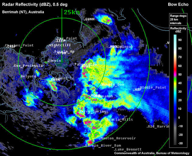
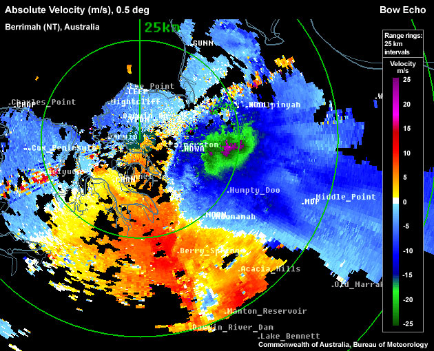
Bow Echo approaching Darwin (Australia) from the east; gust front out ahead, Rear Inflow Notch (RIN) behind the apex of the bow. Aliased Rear Inflow Jet (RIJ) is collocated with the RIN in velocity field.
Use the radio buttons or click the image to switch between reflectivity and velocity imagery:
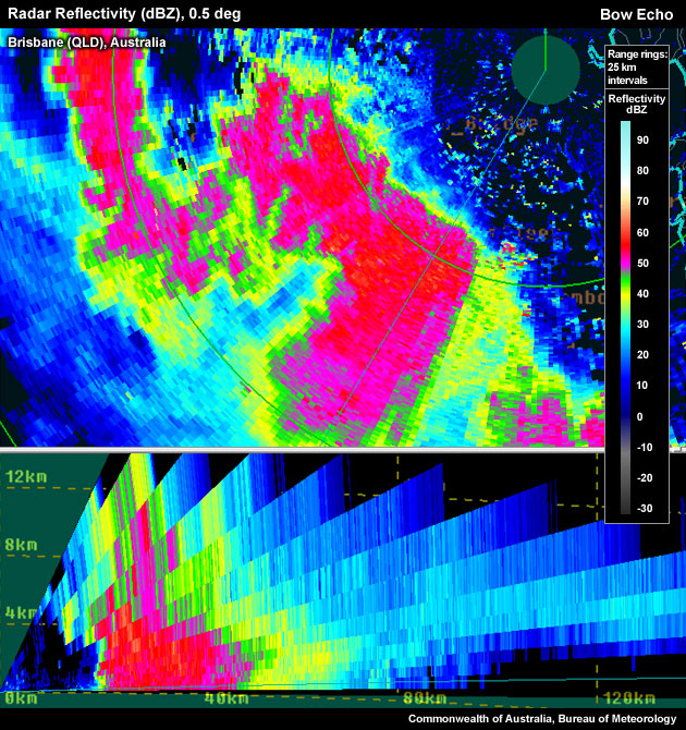
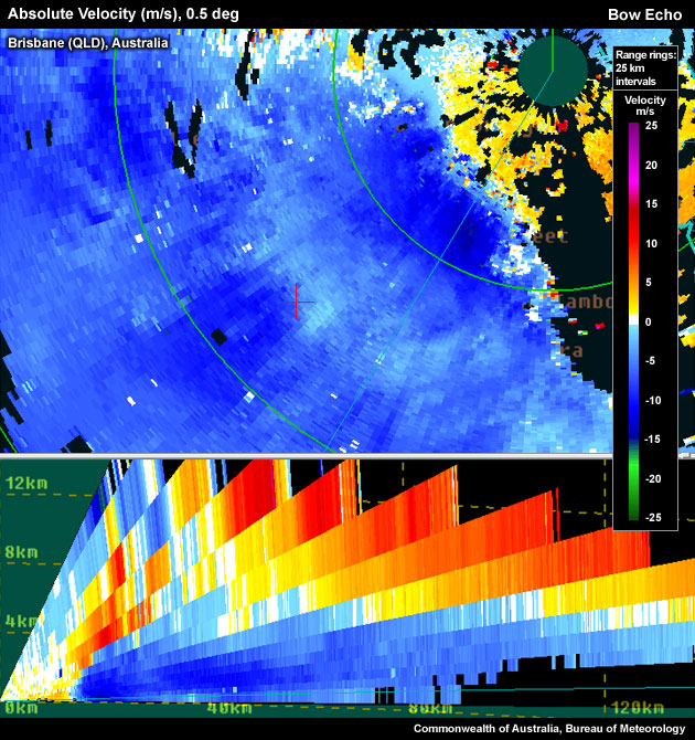
Example of a Bow Echo showing cross sections of the radar reflectivity and absolute velocity.
