< Back to Print Version Table of Contents <
NWSRFS Components
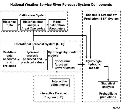
The calibration system of the NWSRFS contains historic streamflow data which are used to establish model parameters. Once such parameters are found, they become the basis for real-time operational model input.
The operational forecast system takes model parameters that are updated for current conditions and combines this information with real-time river data as input to the hydrologic model. Model output is used for short-term forecasts and then used to update parameters for future simulations.
The interactive forecast system allows the hydrologist to adjust and prepare products and forecasts.
The ensemble streamflow prediction component is used to prepare long-term river forecasts based on historic weather and climatic conditions. In this case, a probabilistic value is added to the forecast.
NWSRFS Operational Subcomponents
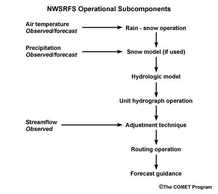
The operational forecast system within the NWSRFS is composed of six subcomponents. There is a rain and snow operations component, a snow model, a hydrologic model (such as the Sacramento Soil Moisture Accounting Model), a unit hydrograph operations component, an adjustment component to match simulated streamflow with observed values, and a routing operations component.
Observed data are critical for the Rain-Snow Operation, Snow Model, and Adjustment Technique sections of the operational forecast system.
Sacramento Soil Moisture Accounting (SACSMA) Model
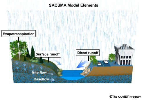
The Sacramento Soil Moisture Accounting model called SACSMA, is a spatially lumped continuous accounting model. This is one of the hydrologic models used in NWSRFS.
The term spatially-lumped means that the model views a particular drainage area as a single unit and uses mean basin precipitation, evaporation, temperature, basin topography, and soil characteristics as inputs. Outputs include direct runoff, surface runoff, baseflow, interflow, and evapotranspiration.
Continuous means that the model variables that account for soil moisture are updated on a day-to-day basis. This allows for creation of an ongoing model condition of soil moisture.
The SACSMA model is ideally suited for the simulation of large drainage basins—greater than 1,000 square kilometers. Because the model simulates storm runoff as well as baseflow, it is also useful for water supply estimates.
Additional inputs to this model include the location of important features such as reservoirs, lakes, and river junctions.
SACSMA Model Components
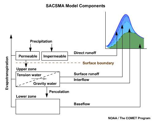
The SACSMA model divides each basin into a surface boundary and two vertical zones to represent soil moisture. The upper zone is for short-term storage, while the lower zone is for most of the soil moisture and for longer-term groundwater storage.
Rainfall that falls on the impermeable surfaces becomes direct runoff. Precipitation may infiltrate into the soil matrix as modeled in the permeable component of the model.
The soil moisture in each zone can exist either as tension water, which is held within the soil matrix by capillary forces or gravity water, which drains freely from the soil matrix.
Tension water is an important concept in the SACSMA model. When the tension water requirements are satisfied, the upper zone is saturated. Any additional water is now gravity water. Gravity water is subject to removal by evapotranspiration, percolation, interflow, or surface runoff. Tension water can only be removed by evapotranspiration. Baseflow accounts for the rest of the soil water in the model.
Each model component contributes to the overall hydrograph. The faster responding parts, such as direct runoff, can be seen as those layers on top of slower-responding components, such as surface runoff, interflow, and baseflow. Together, all of the components combine and influence the shape of a calculated hydrograph.
This approach provides flexibility when calibrating or adjusting the computed hydrograph to match the observed data. Each component can be examined separately and adjusted to match the observed hydrograph.
Additional Resources:
More details are available on the SACSMA Model at the NWS website:
http://www.nws.noaa.gov/oh/hrl/nwsrfs/users_manual/htm/xrfsdocpdf.php
The Antecedent Precipitation Index (API) Model
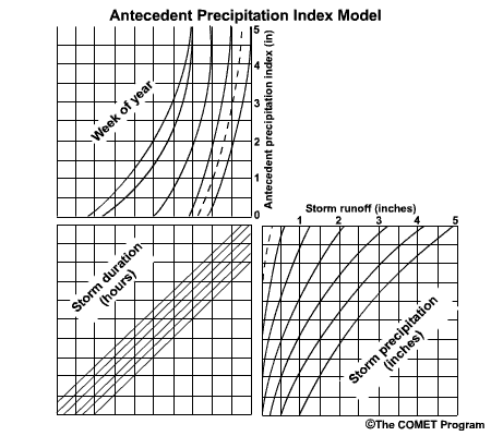
The Antecedent Precipitation Index (API) offers another useful model for producing flood forecasts on a storm-by-storm basis. The API model is a statistical method to estimate the amount of surface runoff that will occur from a basin from a given rainstorm. The index is based on physical characteristics of the basin, time of year, storm duration, and rainfall amount.
Procedures based on the API have been successfully used for many years by River Forecast Centers (RFCs) of NOAA’s National Weather Service. However, as of Spring of 2006, only one RFC uses the API model operationally.
API Example
Click the image above to view animation.
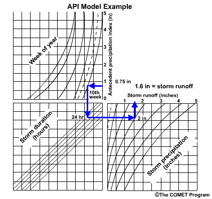
Let’s walk through an example using the API method.
Given an Antecedent Precipitation Index of 0.75 inches:
- Enter the graph and move horizontally to the Week of Year line of interest, in this case week 10.
- Move down to the Storm Duration line of interest, in this case 24 hours.
- Move across to the forecast Storm Precipitation, which is 2 inches.
- Move up to the estimated Storm Runoff.
The estimated storm runoff is 1.6 inches when using this graph and the given set of existing conditions.
API Applications
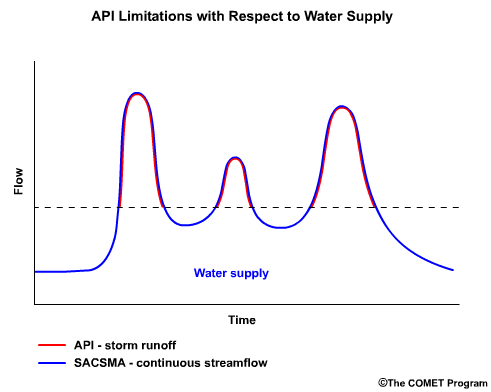
The API based rainfall-runoff model offers a simple method to estimate storm runoff. When properly applied, it generally does a good job forecasting storm specific floods.
The API model is not suitable for water supply estimates however because it is event-based only. In other words, a streamflow estimate can be derived only when a storm occurs. For water supply estimates we must examine continuous streamflow using a continuous accounting approach, such as that used by the Sacramento model.
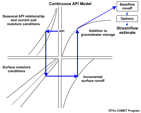
The Continuous API Model
Click the image above to view animation.
The Continuous API model uses a series of equations mapped to four quadrants, a method similar to the event-based API. However, unlike the event-based API, extra computations are required to calculate baseflow.
Each quadrant represents one component of the hydrologic model:
- soil moisture
- surface moisture
- incremental surface runoff
- groundwater storage
In this model, soil moisture is defined as water stored within the soil. Surface moisture is the amount of precipitation intercepted by vegetation, surface depression storage, and any other surface moisture storage.
- The first quadrant accounts for the seasonal relationship between the initial API value and current soil moisture conditions within a basin.
- The value from the first quadrant is used to enter the second quadrant, which accounts for surface moisture conditions.
- The second quadrant value is then used to enter the third quadrant. Here the incremental surface runoff is determined based on surface and overall soil-moisture conditions.
- The next step is to use the third quadrant value to enter the fourth quadrant. This step finds the amount of water that is added to groundwater storage.
At this point, additional equations are used to compute baseflow runoff based on the conditions determined from the four quadrants. Baseflow runoff is based on existing groundwater storage and the amount of water that has recently entered groundwater storage.
This model offers various options such as the ability to account for the effect of frozen ground on runoff, and to make allowances for impervious area runoff and riparian vegetation losses before finally estimating the streamflow.
Additional Resources:
For additional information on the Continuous API see:
http://www.weather.gov/oh/hrl/nwsrfs/users_manual/part2/_pdf/23apicont.pdf
Review Questions:
1. The SACSMA runoff model _____.
(Choose all that apply.)
a) is a distributed model with a high-resolution grid
b) is a spatially lumped model
c) can be used for water supply
d) is ideal for flash flood modeling
2. The SACSMA looks at three levels of a basin: the surface boundary, the upper zone, and the lower zone. What processes are modeled in the upper zone?
(Choose all that apply.)
a) direct runoff from impermeable surfaces
b) surface runoff
c) baseflow
d) interflow
3. The advantage of a continuous API model over an event-based API model is that it can be used for water supply forecasts.
(Choose the best answer.)
a) True
b) False
Review Question Feedback
1. The SACSMA runoff model _____.
(Choose all that apply.)
The correct answers are b) is a spatially lumped model and c) can be used for water supply.
2. The SACSMA looks at three levels of a basin: the surface boundary, the upper zone, and the lower zone. What processes are modeled in the upper zone?
(Choose all that apply.)
The correct answers are b) surface runoff and d) interflow.
3. The advantage of a continuous API model over an event-based API model is that it can be used for water supply forecasts.
(Choose the best answer.)
The correct answer is a) True.
End of Section Six:The National Weather Service River Forecast System