6.1 MCSs Vary in Scale, Models Vary in Resolution

It should be clear to you now that MCSs come in many sizes from small,
isolated bow echoes to systems as large as a very long squall line or MCC.
Mesoscale models are typically thought of as those with 30 kilometer grid spacing
or less. All other factors being equal, the higher the model resolution,
the better it should be at representing MCS structures. But because most
operational models are notoriously poor at predicting the onset and exact
location of convection, they are in many ways unreliable for predicting MCSs.
For example, convective parameterization schemes vary in their ability to
generate convective downdrafts and mesoscale cold
pools. Important details such as these are tremendously significant in determining
any particular model’s ability to forecast MCS evolution.
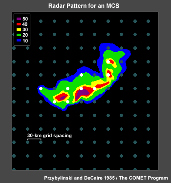
In this hypothetical example, a model with 30 kilometer gridpoint spacing
may initially resolve a midsized MCS; however, it is clear that with this
kind of resolution the model cannot sufficiently depict significant details
such as the updrafts, downdrafts, and other embedded precipitation processes
to properly forecast the MCS's continued evolution.
6.2 MCS Processes and Model Performance

Model errors forecasting convection and MCSs arise from at least two common
sources. One source involves the “initial conditions.” If there
are errors in the initial conditions, then it is very difficult to correctly
forecast convective details. The second obvious source comes about as a result
of having to “parameterize” convective processes in all hydrostatic
mesoscale models and even in non-hydrostatic models with grid spacing of
more than a few kilometers. Convection and other important non-hydrostatic
precipitation processes in MCSs occur on scales much smaller than can be
resolved by most operational mesoscale models. Thus, these processes are
parameterized to simulate their effects on the larger-scale environment.
Parameterization of these details is better than not trying to account for
them at all, but is still quite problematic and can result in significant
departures from reality when it comes to forecasting thunderstorms with models.
6.3 Limitations of Convective Parameterization Schemes

It is important to know and understand the limitations of any particular model’s
convective parameterization scheme. Generally speaking, the stronger the large-scale
forcing, the better the convective parameterization will do with the timing,
location, and amount of heavy precipitation. However, if there is elevated
instability and the environmental forcing is strong, sometimes the model convective
parameterization will not be able to keep up with the supply of moisture and
lift, resulting in the grid-scale precipitation scheme trying to make a cumulonimbus
with an updraft as wide as an entire grid box! Obviously such a wide, intense
updraft produces too much latent heating, too much precipitation, too low surface
pressures, and other inappropriate feedback.
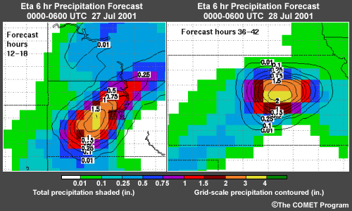
Consider these examples from the 22 kilometer operational Eta Model. It
began making precipitation bull's-eyes over the plains in mid-July 2001 and
continued generating such episodes even after the 24 July 2001 model upgrade.
These precipitation bull's-eyes with amounts over four inches, mostly in
a six-hour period, were being generated primarily by the grid-scale scheme
in high-CAPE environments with strong mesoscale forcing. These forecast events
were spurious and unphysical but occurred under conditions favoring strong
convective systems with heavy rains. These grid-scale storms became the model's
focal point for convergence, vertical motion, and instability release, causing
the model to miss the forecast where the MCS actually occurred.
6.4 What Can Go Wrong?
| Model Convection Issues |
NWP Model Accuracy |
| 1. Convective initiation |
Affected by the synoptic scenario:
- Accuracy of the
initial conditions
- Resolution of
the model
- Convective parameterization
used
|
| 2. Convective system evolution |
| 3. Total amount of precipitation |
| 4. Accompanying weather hazards |
Not predicted by NWP models
|
| 5. Impact on other downstream weather
elements such as clouds and temperatures |
Limited by errors in convective system evolution prediction |
There are five aspects of convection to address in a forecast: 1) convective
initiation – including both timing and location of the onset of convection,
2) convective system evolution – including the size of the area affected
and the propagation and duration of the system, 3) the total amount of precipitation,
4) the accompanying weather hazards, and 5) the impact on other downstream
weather elements such as clouds and temperatures.
The accuracy of the first three of these factors in the model forecast is
affected by the synoptic scenario, the accuracy of the initial conditions,
the resolution of the model, and the particular convective parameterization
used.
The fourth factor isn’t predicted by any NWP model.
The fifth factor is predicted to some extent by the models, but is limited
by errors in the second factor.
- No one "better" parameterization scheme
- Each has strengths and weaknesses
- None is consistently good
- Forecasts of forcing features are more accurate than convective
forecasts
- Rely more on predicted forcing and inhibiting features
|
No parameterization is routinely “better” than another. Each
has a different mix of strengths and weaknesses in handling these different
aspects of the forecast. None is consistently good.
In contrast, a model forecast of important features such as fronts, jet
streaks, capping inversions, and the presence of a sea breeze or dryline
will be more accurate than the model forecast of convection itself (although
feature position may be off).
Thus, you should rely more heavily on the forcing and inhibiting features
predicted by the model than on the convection forecasts themselves.
6.5 Review Question: Factors Affected by the
Synoptic Scenario
The accuracy of which of these factors in the model forecast is affected
directly or indirectly by the synoptic scenario? Select all that
apply.
a) Hail size
b) Convective initiation
c) Total amount of precipitation
d) Maximum outflow winds
e) Impact on downstream temperatures
f) Convective system evolution
Review Question Feedback
The correct answers are b), c), e), and f).
The accuracy of convective initiation, convective system evolution, and
total amount of precipitation is directly affected by the synoptic scenario.
Impact to downstream weather elements, including temperature, is predicted
to some extent by the models. However, accuracy is limited by errors in
predicting convective system evolution. Accompanying weather hazards, such
as hail size or maximum outflow winds, are not predicted by NWP models.
6.6 Review Question: Model Forecast Adjustments
Imagine you are forecasting for a location downstream of an MCC that is
currently weakening. Model fields show development of a mid- to upper-level
circulation center associated with the MCC propagating over your area within
the next 24 hours, along with moderate-to-heavy precipitation amounts.
However, there is no evidence on satellite and radar observations that a
vortex exists and no other features are evident to help focus or enhance
the precipitation. What adjustments to the model forecast may be necessary?
Select all that apply.
a) Decrease forecast precipitation amounts
b) Increase forecast precipitation amounts
c) Decrease cloud cover and increase daytime temperatures
d) Increase cloud cover and decrease daytime temperatures
Review Question Feedback
The correct answers are a) and c).
The formation of a mid- or upper-level circulation in the model is a clue
that the model’s convective parameterization scheme kicked in and created
the vortex in response to the latent heat being released by the convection
in the model. Even though the convective parameterization scheme may have “functioned” correctly,
the resulting circulation may be an artifact propagated downstream in the model
that is acting to generate the subsequent cloudiness and precipitation in your
area. If you’re sure the vortex isn’t really there, then it is
probably appropriate to decrease forecast precipitation amounts and expected
cloud cover and to increase daytime temperatures (as long as other precipitation-enhancing
factors are not present).
6.7 What about ~ 10 km Resolution?

Click the image above to view animation.
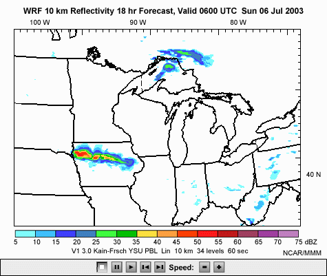
Most MCSs are of sufficient size to be depicted but not fully resolved by
a 10 kilometer model. You may recall from the “How Mesoscale Models
Work” module that an NWP model can show the
presence of a feature five grid spacings across, or in this case, 50 km.
However, a feature would have to be 7 to 10 grid spacings in size to be more
properly handled. Thus, a 10 kilometer model with suitable physical parameterizations
can generate many features of a realistic mesoscale convective system. It
is important to remember that even at 10 kilometer grid spacing, the model
timing and placement of convective initiation will vary depending on the convective
parameterization being used. In fact, the timing and track of model MCS forecasts
have little skill. Sometimes they’re good, sometimes they are not, but
they are definitely not reliably good! One major contributor to poor MCS evolution
forecasts is the inability of even a model of this resolution to properly
generate and evolve the system gust front and cold pool. However, at 10 km
resolution, models may do a good job of signaling the likelihood of an MCS
in the general region.
6.8 MCS Prediction with Non-Hydrostatic Models
- Storm-scale models with grid
spacing no greater than 5 km:
- ARPS (the Advance Regional Prediction
System)
- Some configurations of MM5, WRF, and COAMPS
- Studies show ARPS does credible modeling of convective storms
- ARPS with 2-km grid spacing generates new cells along a gust front
and depicts MCS evolution
- Better accuracy in strongly forced weather patterns than in weaker,
less obvious cases
- Accuracy depends on details of initial conditions
|
Only in the recent history of NWP models have computational resources and
new non-hydrostatic model code allowed routine investigation and modeling
of convection at extremely high resolution without convective parameterization
schemes. Examples of this new generation of storm-scale models with grid
spacing of no greater than 5 km include ARPS (the Advance Regional Prediction
System) and some configurations of MM5 and WRF (the Weather Research and
Forecasting model). Studies examining ARPS’ explicit convection (in
other words, without parameterizing convective processes) indicate that storm-scale
models with state-of-the-art model physics can do a credible job of modeling
convective storms. With 2 kilometer grid spacing, the ARPS model has clearly
demonstrated the ability to generate new cells along a gust front and depict
MCS evolution. However, even these cutting edge models are much better at
forecasting convection initiation and evolution in strongly forced weather
patterns than they are in the weaker, less obvious cases. It is important
to remember that despite the remarkably realistic-looking detail produced
by these advanced models, accurately forecasting the placement, timing, and
amount of precipitation depends on details in the initial conditions that
often are not adequately observed.
6.9 Review Question: Convective Parameterization
True or False? Convective parameterization in the WRF model is routinely better
than that in the Eta Model.
Review Question Feedback
The correct answer is "False." No convective parameterization is
routinely better than another.
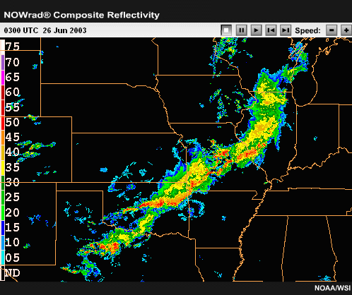
6.10 Review Question: Comparing Models
Although higher-resolution models provide more detail, we must be careful
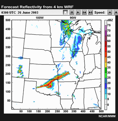
when using them to forecast convection. As an illustration, let’s compare
reflectivity forecasts from the 10-km and 4-km WRF models to the radar
loop showing what actually occurred in the central U.S. during the night
of 25 June 2003. Please review the data below and answer the question that
follows.
 Click the image above to view animation.

Click the image above to view animation.

Click the image above to view animation.
How well did the models do? Select all correct answers.
a) The 4 kilometer WRF was better than the 10 kilometer WRF in forecasting
the squall line from eastern Missouri to northwest Texas.
b) Both models missed the convection over Illinois.
c) The 10 kilometer WRF was better than the 4 kilometer WRF on forecasting
disorganized thunderstorms over the Texas Panhandle.
d) Both models were correct in forecasting bow echoes along the line from
Arkansas to the Red River area of Texas/Oklahoma after 0600 UTC.
e) The 10 kilometer WRF was better than the 4 kilometer WRF on timing of the line in Oklahoma
and northwest Arkansas at 0600 UTC.
Review Question Feedback
The correct answers are a), b), and d). This example demonstrates that
higher resolution models are not necessarily perfect. They may often be
good at forecasting the anticipated storm structures and mode of convective
organization, but can, with great detail, miss the actual location or timing.
6.11 Using Mesoscale Models to Forecast MCSs:
A Summary
At this point, there are several reasonable approaches for applying mesoscale
models to MCS prediction. The first and most important is to use model output
to look for favorable synoptic and mesoscale patterns and associated
buoyancy and shear profiles conducive to MCS formation. Of course, care must
always be taken to be alert for synoptic positioning errors and particular
kinds of model biases.
(View in-depth
discussion on this topic below.)
Second, the model parameterizations themselves may yield useful diagnostic
fields. For instance, the operational Eta and RUC produce fields of convective
cloud tops. Glancing at those can give a general idea of where there is a risk
that if convection occurs, it will be tall rather than low-topped. The Kain-Fritsch
parameterization scheme outputs a convective mass flux field that indicates
how vigorous it expects the convection to be. Where the mass flux is near the
maximum value, cloud-scale updrafts may be expected to be unusually strong
and severe weather is possibly more likely, even if the model-predicted precipitation
is light.
Third, forecasters should watch out for exceptionally large vertical velocities
colocated with very heavy precipitation in model forecast runs that use convective
parameterization. Such features indicate that the model is trying to make
an unphysical large-scale cumulonimbus! However, it also means you need to
inspect the situation carefully because even if the model feature has large
errors, an MCS may be likely in the general vicinity.
And fourth, studies have shown that high-resolution mesoscale models
without convective parameterization (less than or equal to 6 kilometer
grid spacing) are quite good at forecasting the occurrence of convection in
a region, though not at a particular point. They are even pretty good at forecasting
the mode of convection in strongly forced situations. This means a well-constructed
model of sufficient resolution can give good guidance as to whether storms
will be isolated, multicellular, or evolve into larger convective systems. Again,
this is especially true in strongly forced weather patterns. The good news
for forecasting MCSs is that the larger the system, the more likely the model
is to forecast it, even out to 48 hours in advance. Unfortunately, in the
weakly-forced scenarios, which are more difficult for humans to predict, the
models also have a much more difficult time. In these scenarios forecasters
must place more emphasis on conceptual models and pattern recognition.
In conclusion, the best advice is to realize that if the highest-resolution
mesoscale model is predicting a large area of long-lived convection, the
situation likely warrants close watching by you, the forecaster, even though
the predicted timing and location of the system may be off.
NWP In Depth: |
| A realistic example of using mesoscale models
to forecast MCSs was presented in a recent paper by Gale and coauthors.
They examined weakly-forced nocturnal MCSs and tried to assess atmospheric
factors affecting MCS dissipation. They evaluated a number of observed
and Eta Model parameters and found that the only potentially valuable
predictor of dissipation was a forecast decrease in the 850-hPa Theta-e
advection in the area of the MCS. They also noted that the 850-hPa Theta-e
advection bull’s-eye
forecast by the Eta Model was very closely correlated with the location
where real MCSs were likely to initiate. This is another example of using
a mesoscale model to forecast MCS initiation and dissipation, not by
taking the model convective precipitation forecasts literally, but by
using the model output in an educated manner as part of the forecast
process. |
End of Section 6.0: MCSs and NWP
