5.1 What is an MCC?

Mesoscale convective complexes (MCCs) are a still larger form of convective
organization than we have discussed to this point. It was Maddox in 1980
who called attention to this class of larger convective systems by coining
the term MCC. MCCs were the first larger convective system type (other than
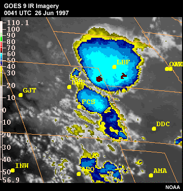
tropical cyclones) to be identified. A system is classified as an MCC based
on its size and duration characteristics as identified in IR satellite imagery.
The physical characteristics of an MCC include a general cloud shield with
continuously low IR temperatures less than -32°C over an area >= 100,000
km 2, with an interior cold cloud region with temperatures less than -52°C
having an area >= 50,000 km². This corresponds to an average diameter
of ~ 600 km (or ~320 n mi). These size criteria must be met for at least
six hours or longer. Now that meteorological radars are more common, we have
learned that many different convective storm structures occur under these
enormous anvil shields. Additionally, many MCSs, some of which are quite
large and long-lived, never meet the exact size and duration criteria to
be labeled an MCC. This is why the term MCS is now more commonly used to
describe the entire range of organized convective systems. Nonetheless, because
they have been documented and quantified using satellite imagery in otherwise
data-sparse regions around the globe, MCCs remain a useful area of study
and recognition.
5.2 Favored Synoptic Setting


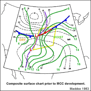
MCCs are most often observed at night, in areas in which the boundary layer
is stable. Observational studies suggest that MCC structure and evolution
are more dependent on interactions with large-scale forcing features than
the evolution we described for squall line MCSs. Specifically, case studies
have shown that MCC initiation is usually associated with a weak large-scale
frontal zone and the eastward progression of a weak shortwave trough and
associated vorticity maximum in the middle troposphere. MCCs tend to occur
on the anticyclonic side of a broad, weak westerly jet stream in a location
where a low-level jet is delivering moisture-rich air into the genesis region.
In 2000, authors Laing and Fritsch published a paper examining the environments
conducive to MCCs in four regions outside the United States including Africa,
Australia, China, and South America. They contrasted the MCC-producing synoptic
and mesoscale environments to those in the United States and concluded that
the environments are all very similar in terms of both their dynamics and thermodynamics.
5.3 MCC Life Cycle

The life cycle of an MCC is classified as having four stages: 1) Genesis,
2) Development, 3) Mature, and 4) Dissipating. These stages could just as
well apply to any MCS with Mature corresponding to the system at its maximum
extent. During the genesis portion of an MCC’s life cycle the convective
structures that make up the future MCC may include multiple squall lines,
bow echoes, or isolated convective cells, each evolving through its own life
cycle, with each system contributing to the expanding cold pool and anvil.
During the later stages of evolution, however, a large stratiform precipitation
region dominates the MCC, as it often does in the later stages of squall
line evolution. An observation study of MCCs by McAnelly and Cotton noted
that on average MCCs last 10 to 12 hours from storm initiation to the time
that they shrink below the minimum size criteria in satellite imagery.
5.4 MCC to MCV


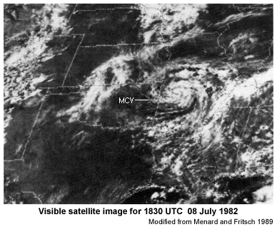
The flow field in the later stages of an MCC is characterized by divergent
anticyclonic outflow near the surface and aloft within the anvil, with convergent
cyclonic flow at midlevels. Like the northern line-end vortices of squall
lines discussed earlier in this module, this mid-level cyclonic flow is often
referred to as an MCV (or sometimes MVC as discussed earlier). These can
be generated by large MCSs, including MCCs, and are most likely to survive
beyond their parent MCS when the environmental vertical wind shear is weak.
These conditions are often met in the classic weak synoptic setting for derechoes
under a large-scale ridge.
Mid-level cyclonic vortices, as documented by Trier and coauthors in a 2000
paper, are frequently observed to be the focus of subsequent convective outbreaks.
In fact, 9 of 16 MCVs they observed in the central U.S. during the convective
warm season of 1998 were responsible for initiating subsequent deep convection
and heavy precipitation. Thus, MCVs spawned by some MCSs are a significant
indicator of the location of possible future convection initiation.
5.5 Elevated Convection

The buoyancy source for any MCS/MCC may come
from the boundary layer, as in many warm season, daytime convective scenarios
or from an elevated layer of instability above a cooler surface-based inversion.
This module has primarily focused on MCSs that feed off boundary-layer-based
instability. Elevated convection is an especially common cause of MCCs and
nocturnal MCSs that form well north of weak surface fronts. Details of forecasting
elevated convection are beyond the scope of this module, but it is important
in this context to realize that predicting MCSs that form as a result of
elevated layers of instability is an especially difficult forecasting challenge.
The cold pool/shear balance concepts discussed for boundary-layer-based convection
earlier in this module do NOT apply to systems with elevated buoyancy sources.
The curious student is referred to Colman 1990 and Moore and coauthors 2003
to learn more about elevated instability and MCSs.
5.6 Associated Threats

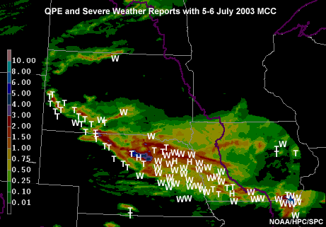
MCCs often last for 6 to 12 hours and are especially known for producing
heavy rain and even widespread flooding as shown in this example from July
2003. The quantitative precipitation estimate from this case showed as much
as 6 to 8 inches of rain in some places. MCCs are also associated with severe
winds, hail, and tornadoes usually during the early phases of their evolution.
The July 2003 event also had this tendency, with tornadoes and large hail
predominantly occurring during the first half of the system’s evolution,
and severe winds characterizing the second half. This makes sense because
many nocturnal systems that reach MCC-size and duration criteria evolve from
surface-based MCSs that initiated earlier in the day. Because of their size,
duration, and extensive lightning MCCs are a significant threat to aviation.
Investigations of MCCs around the globe have concluded that they do indeed
occur worldwide over both land and ocean surfaces. Because they are so common
and generate so much heat and moisture exchange and are responsible for producing
extensive precipitation, MCCs are an important part of the global hydrologic
cycle.
5.7 Review Question: Identify Importance
of MCCs
Why should we forecasters be concerned about MCCs? Choose all that apply.
a) Occur worldwide over land and ocean
b) Especially known for producing heavy
rain and widespread flooding
c) Known for a large area of relatively warm
cloud-top temperature
d) Produce tornadoes in their later stages
e) Significant threat to aviation
f) Can produce an MCV that moves downstream
and initiates convection at a later time
g) Often caused by the result
of elevated convection, which is especially difficult to forecast
Review Question Feedback
All answers are correct except d) “Produce tornadoes in their later
stages” and c) “Known for a large area of relatively warm cloud-top
temperatures.” MCC systems can produce tornadoes, but usually in the
early stages of their life cycle. These deep convective systems are actually
characterized by a large area of relatively cold cloud-top temperatures on
GOES IR satellite imagery.
5.8 Review Question: Identifying MCCs
Please select the best answer below.
MCCs are uniquely identified by:
a) Very large, bow echo pattern on radar
b) Dense
area of strikes in lightning data
c) General cloud shield with continuously low
temperatures on IR satellite data
Review Question Feedback
The correct answer is c). MCSs often exhibit a dense area of lightning
strikes, while some take on a large bow appearance on radar. However,
many do not meet MCC criteria. The physical characteristics of an MCC
include a general cloud shield with continuously low IR temperatures
less than -32°C
over an area >=
100,000 km², with an interior cold cloud region with temperatures
less than -52°C
having an area >= 50,000 km². This corresponds to an average diameter
of ~ 600 km (or ~ 320 n mi).
End of Section 5.0: Mesoscale Convective Complexes

