4.3.1 Bow Echo: Cross Section View

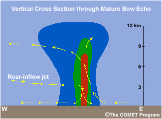
Vertical cross sections through the core of a bow echo depict a strong vertically
erect updraft at the leading edge of the system. There is also a strong elevated
rear-inflow jet at midlevels impinging from the rear of the system to just
behind the updraft. Then it abruptly descends and spreads out along the surface.
Above the rear-inflow jet, the updraft current turns rearward feeding into
the stratiform precipitation region. It should be noted that the preferred
method is to assess rear-inflow motion in a storm-relative sense to verify
the true strength of this feature. However in this example, storm-relative
velocity was not available.


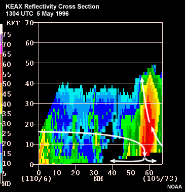
Compare the conceptual model to these radar-reflectivity and velocity cross
sections through a bow echo. Note that in this case the radar is to the left
of the storm, which is moving away from the radar. The reflectivity cross
section shows a very strong deep cell right at the leading edge of the system
with very little trailing stratiform precipitation. Also note the weak echo
overhang on the front edge of the system (the downshear direction). In the
velocity image the rear inflow (36-50 kt) remains quite elevated (10,000
ft or ~ 3 km) all the way to the leading line convection before diving toward
the surface. Additionally, the system updraft is quite erect (depicted by
the gray area with a hint of green, which is tilted only slightly rearward).
These factors all indicate that the vertical wind shear was strong on this
day.
4.3.2 Bow Echo: Cross Section Pressure Field


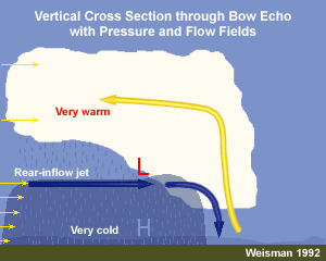
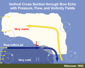
The pressure field is characterized by a strong mesohigh at the surface, associated
with the cold pool, and a strong mesolow at midlevels, just above the mesohigh.
Because they tend to occur when CAPE values are large, bow echoes have exceptionally
warm updrafts above the cold pool. The strong warm pool aloft combined with
the strong surface cold pool contributes to the development of an exceptionally
strong rear-inflow jet toward the mid-level mesolow. Just like we saw in the
Squall Line section, the strength of the RIJ is important because the stronger
the storm-relative flow in the RIJ, the greater is the potential for damaging
winds at the surface!
4.3.3 Radar-Observed Rear-Inflow Notch


As mentioned in the conceptual model discussion, there is a reflectivity
feature created by the impinging RIJ called the rear inflow notch or RIN.
Detecting a RIN can be useful in identifying the increased potential for
strong winds within a bowing structure. (NOTE, the absence of a RIN does
NOT mean there won’t be strong surface winds.) The RIN is a useful
concept though because it is a reflectivity-only feature meaning it can be
observed even when the radar-viewing angle through a bow echo is unfavorable
for determining the actual wind velocity. Analysis of both these events showed
that in both cases the rear-inflow jet descended and created damaging surface
winds.
This next review question refers to the case scenario from the first section
of this module. Test your skill at locating the bow echo and associated RINs
in the data from this case.
4.3.4 Review Question: Locate Bow Echo

Click the image above to view animation.
In the ~ 45-minute long radar loop from 0113 UTC to 0204 UTC on 26 June
2003, a bow echo developed in the squall line. The bow echo had at least
one rear-inflow notch (RIN).
Stop the loop on the last frame and draw the location of the bow and any associated
RINs.
Review Question Feedback

Click the image above to view animation.
Expert Answer: The bow echo developed in west-central Illinois and moved
northeastward or almost perpendicular to the line movement, in the direction
of the mean low-level shear vector. Two RINs were evident at 0204 UTC, just
south of the northern-end vortex. Given that the radar beam did not pass through
excessively heavy precipitation before reaching the bow, it does not seem
likely that these RINs are the result of attenuation. Luckily, Scott AFB was
spared the worst of this event. The only official reports of severe winds
occurred to the north, with the bow echo.
End of Section 4.3: Bow Echoes - Features
