3.7.1 CONUS Example


Composite Radar Reflectivity Loop

Click the image above to view animation.
Easterly squall line motion is observed in subtropical
latitudes as well. Occasionally in the southwestern U.S. during
the summer the synoptic flow pattern creates a vertical wind shear profile
that supports east to west motion across the desert southwest as
shown by this case from western Arizona. The low-level shear vector is toward
the southwest, and so is the system propagation. This squall line
created damaging straight-line winds, large hail, a weak tornado, and flash
flooding! This case re-emphasizes the importance of the vertical wind shear
profile in determining MCS evolution regardless of the latitude.
Recall our case scenario in Section One. Sergeant Slade was
able to discern where the squall line was in its life cycle
and how strong the shear was relative to the cold pool. Can you? In the next
exercise you will have a chance to test your skill at judging the stage of
squall line development and the likely strength of the vertical wind shear.
3.7.2 Review Question: Squall Line Life
Cycle
Based on the data provided, answer the following questions:


Click the image above to view animation.
1. How strong is the relative low-level shear?
a) Weak
b) Moderate
c) Strong
d) Can’t tell
2. How about the relative strength of the cold pool versus the shear?
a) Cold pool in balance with the shear
b) Cold pool stronger than shear
c) Cold pool weaker than shear
3. What stage is the squall line in?
a) Early
b) Mature
c) Dissipating
d) Regenerating
e) Can’t tell
Review Question Feedback
Expert Answer:

Same date: 25 Jun 2003

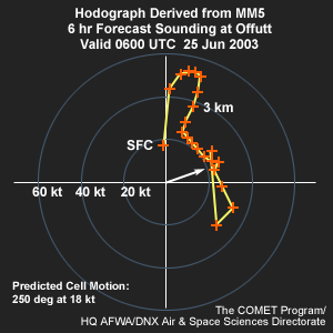
Let’s assume the forecast sounding for Offutt AFB valid 0600 UTC best
represents the squall line’s current environment. The sounding’s
hodograph indicates a 0 to 3 kilometer shear vector from the southwest about
20 kt (~ 10 m/s). Since the squall line is oriented almost parallel to this
vector, shear component perpendicular to the line is much smaller. So, this
is a squall line in a weak shear environment. Therefore, the answer to question
one is a).
It would be very difficult to directly measure the relative strength of
the cold pool with existing operational sensing systems. However, the persistent
eastward bowing of the squall line front and weakening of the precipitation
behind it suggests that the cold pool is stronger than the shear. The answer
to question two is b).
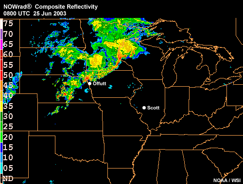
In the latter part of the NOWRAD composite reflectivity loop, the system
assumes a “pork chop” appearance and has a hint of a northern
end vortex. Most of the precipitation associated with the cold pool has begun
shifting to the northwest part of the system. So, the squall line is likely
in the early stages of dissipation. The answer to question three is c).
In fact, the squall line did become less organized after 0800 UTC although
this is not shown in the data provided here.
End of Section 3.7: Squall Lines - Application
End of Section 3: Squall Lines


