3.3.1 Shelf Cloud

As relatively warm and moist air is forced upward by the advancing gust front, a menacing-looking feature called a shelf cloud may be observed. It usually heralds a period of strong, gusty winds.
Mesoscale Meteorology
Severe Convection II: Mesoscale Convective Systems
3.3 Features

As relatively warm and moist air is forced upward by the advancing gust front, a menacing-looking feature called a shelf cloud may be observed. It usually heralds a period of strong, gusty winds.
Review this radar loop and then fill in the blanks in the statements below.
The system in this loop is in its mature stage and evolving in a moderate wind shear environment. The northern line-end vortex expands rearward in the loop because the system’s ______________ (a) length (b) upshear tilt (c) warm pool strength aloft is increasing.
Stronger ambient shear would probably keep the line-end vortices _______________ (a) from forming this early (b) closer to the leading edge. If this line were evolving in weak shear, it would probably not exhibit ___________ (a) strong convective cells (b) a stratiform precipitation region (c) both a and b at this stage of its evolution.
The northern line-end vortex expands rearward because the system is tilting more upshear at this stage of its evolution. Stronger ambient shear would probably keep the line-end vortex closer to the leading edge because it would prevent the strong upshear tilt we see evident (by the existence of the broad stratiform precipitation) in this loop.
Weak ambient shear would not be able to maintain such strong leading line convective cells for this long because the front-to-rear flow would remain shallow as it tilts rapidly rearward over the cold pool. However, weak shear would still lead to the development of a stratiform precipitation region.
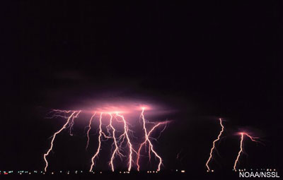
As with any convection accompanied by thunder, lightning is a likely hazard. However, the distribution of cloud-to-ground lightning strikes in space and time can give the forecaster information about a system's type and evolutionary state. This is especially true with squall lines.
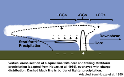
As seen in this conceptual model, negative cloud-to-ground strikes (-CGs) dominate the region of the convective core on the downshear side of the system. Positive cloud-to-ground strikes (+CGs) are most common in the stratiform precipitation and downshear-anvil regions.
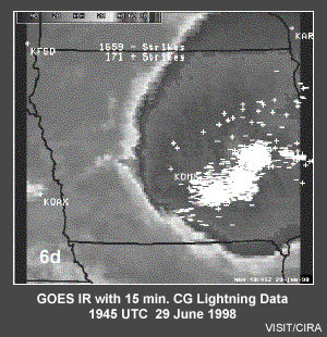
Such a pattern can be readily seen in GOES IR satellite data overlayed with lightning strike data. In this mature squall line over southeast Iowa, note the bowing of the dense –CG area and scattered +CGs in the northwest part of the system. Damaging winds, large hail, and tornadoes occurred as the MCS moved through the state. In fact, the Davenport NEXRAD radar was knocked out by lightning. So, in this case, with no real-time radar data, the lightning data was used in combination with the satellite imagery and was critical to the success of the warning-decision process.
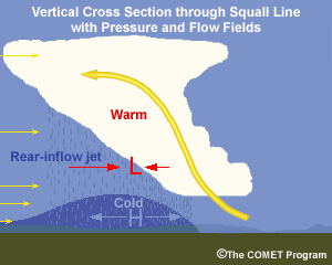
As the squall line evolves in its mature stage, the spreading of the convective cells rearward transports warm air aloft. In addition, the deeper portion of the surface cold pool also extends rearward, in response to the rearward expanding rain field. Shown in cross section through a squall line, a pool of warm air aloft over a cold pool at the surface produces lower pressure at midlevels and higher pressure at the surface. The wind field responds by diverging outward from the high at the surface and converging toward the mid-level low pressure. It is this flow converging in from the rear of the system at midlevels that creates the rear-inflow jet (RIJ).
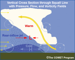
In-depth: Horizontal Vorticity:
The concept of considering the role of horizontal vorticity and vertical wind shear in controlling convective storm structure and evolution is introduced more thoroughly in the module, Principles of Convection III: Shear and Convective Storms. In summary, as vertical wind shear increases, the interaction between the shear and the cold pool becomes an additional factor that can enhance the lifting on a preferred flank of a convective storm. This enhanced lifting occurs even in a relatively uniform environment. Horizontal vorticity is a useful concept for describing shear/cold pool interactions. Throughout this module you have the choice to toggle on or off overlays that convey the horizontal vorticity field in many of the graphics depicting the processes controlling MCS structure and evolution.
We have introduced how a squall line evolves from a downshear- to an upshear-tilted system and develops a rear-inflow jet. Since the vorticity field and pressure field must be consistent, we can explain system evolution using both fields. Consider the processes discussed in this module and place an H or an L in the blank boxes in the graphic below to indicate the relative pressure at the indicated locations.
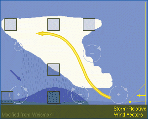
Expert Answer:
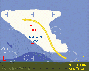
Starting from the bottom left, we see the wake low, created by the descent of a portion of the warm air from the real-inflow jet. We also see the mesohigh within the cold pool. This low-level mesolow interacts with the warm pool mesolow at midlevels, creating the source of the rear-inflow jet. At the upper levels of the storm system, we find higher pressure as a result of the updraft overshooting the tropopause, where it is now cooler than the environment. The pressure field is largely hydrostatic, so it must be consistent with the thermodynamic field, which is also labeled in the answer diagram.
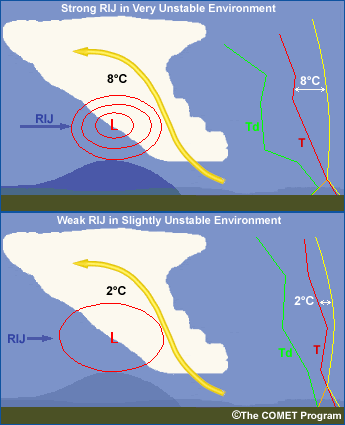

The strength of the rear-inflow jet within an MCS is directly related to the strength of the system’s internal buoyancy gradients created by the contrast between the coolness of the cold pool and the warmness of the updraft. The schematics on this page contrast two hypothetical environments. The lifted surface parcel shown in yellow is highly unstable in the top example with a lifted index value of –8, while the bottom case is less unstable with an LI of only –2. These types of differences in instability contribute to important differences in overall system strength. For one, the greater the thermal contrast between the cold pool and the warm rising updraft, the stronger the RIJ. It’s important to note that the strength of the cold pool (temperature difference from the local environment) is directly related to the degree of the environmental instability. The potential cooling within the cold pool increases for both increasing instability as well as increasing mid-level dryness (as shown in the top frame). Correspondingly, the rear-inflow jet strength typically increases with increasing amounts of environmental instability. The tendency for mid-level dry air to contribute to the severity of an MCS shows up in climatological studies of squall lines that create extensive wind damage. These are discussed further in the Bow Echo section.
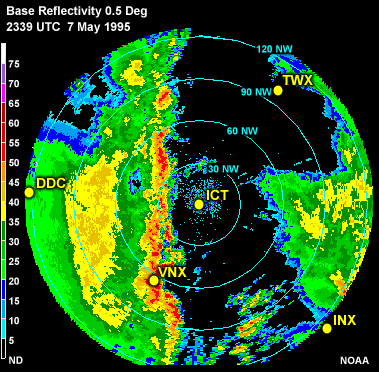
Radar Reflectivity Image
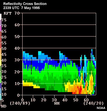
Radar Reflectivity Cross Section
Radar Base Velocity Cross Section
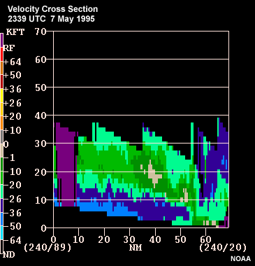
Question: Given the available data, what stage of formation is this squall line in?
What features visible in the data tell you it is in this stage?
The reflectivity imagery shows a strong, primarily solid line of convective cells at the leading edge and a broad region of stratiform precipitation separated from the leading line by a weak echo channel or transition zone. The velocity cross section reveals a distinct rear-inflow jet and a distinct rearward tilt to the system. Together, these features are indicative of a squall line in its mature stage. Notice in the reflectivity loop that the reflectivity levels appear to be decreasing. The system may be beginning to decay, but more likely we are just seeing the effects of the system moving closer to the radar (i.e., we are seeing the lower levels of the storm).