3.2.1 Early Squall Line Evolution: Weak-to-Moderate
Wind Shear
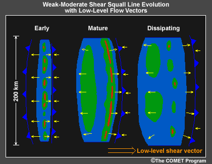
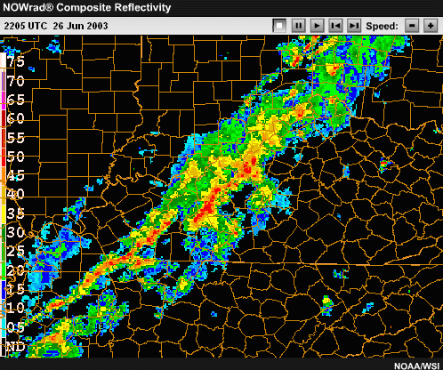
Click the image above to view animation.
Once formed, squall lines often display a characteristic life cycle, starting
as a narrow band of intense convective cells and evolving to a broader, weaker
system over time. However, the time over which this evolution takes place
and the specific structures that develop within the squall line depend strongly
on the magnitude of the low-level vertical wind shear. In general, stronger
shear environments promote longer-lived and more severe weather producing
systems.
During the evolution of a weakly-to-moderately sheared squall line,
a system is composed of mostly independent convective cells. The line
often appears quite narrow, with the surface cold pool generally confined
to a small region around the convective cells. As the squall line matures,
it is typically characterized by a fairly solid line of strong leading
edge convective cells. An extensive surface cold pool extends rearward
from the leading edge in association with the expanding region of stratiform
precipitation. A narrow region of very light precipitation, referred
to as a weak echo channel or transition zone, is often observed between
the leading line convection and the stratiform precipitation region.
During the dissipating stage of the squall line the leading convection
weakens as the surface cold pool surges ahead of the system. Although
the convective cells have weakened, the stratiform precipitation region
may last for several hours.
3.2.2 Early Squall Line Evolution: Moderate-to-Strong
Wind Shear
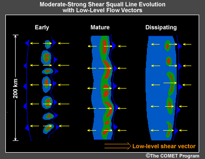

Click the image above to view animation.
In strongly sheared environments, the evolution of a
squall line begins with an initially narrow line of strong convective
cells, with light precipitation often extending downshear of the convective
cores. Some of the cells may be supercells. As the system matures, the
narrow line of strong cells persists, with bow-shaped segments of cells
also beginning to develop. Lighter precipitation begins to extend somewhat
rearward (upshear), but to a lesser extent than in weaker shears. In
the dissipating stages, the leading cells weaken and become more scattered
and the region of lighter precipitation extends even farther rearward
(upshear).
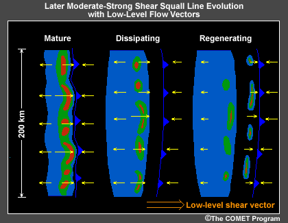
Note: While these conceptual models of squall line evolution
are very useful, the real world is often more complicated. Regardless
of the characteristic strength of the vertical shear whenever an MCS
system cold pool moves away from the original decaying cells, a new line
of cells may be triggered even as the cold pool weakens. This is especially
likely if the decaying system and leading cold pool encounter a more
favorable environment. When this occurs, the system may again strengthen,
looking more like the mature stage, and continue its evolution as before.
This process has been observed to considerably extend the lifetimes of
convective systems.
3.2.3 Mature Squall Line Structure: Weak-to-Moderate
Wind Shear

Click the image above to view animation.

As a squall line matures, it typically develops rotation at each end.
The development of these line-end vortices is most apparent and significant
for relatively short lines (less than 200 km, 110 n mi, in length). As
we’ll
discuss later, line-end vortices in close proximity to each other in bow
echoes are given the special name bookend vortices. This development is
schematically presented here for a 150 kilometer (80 n mi) long squall
line evolving in an environment characterized by weak-to-moderate low-level
shear.
Line-end vortices usually develop during the early to mature stages or
between two to four hours into the lifetime of the convective system,
just behind the zone of most active convection. When line-end vortices
first develop, the cyclonic and anticyclonic vortices are often of nearly
equal strength, promoting a symmetric, bowed shape in the precipitation
field. However, if the vortices last for more than two to three hours (i.e.,
beyond four to seven hours into the lifetime of the system), the
northern, cyclonic vortex tends to become stronger and larger than the
southern, anticyclonic vortex. As this occurs, the convective system becomes
asymmetric, with most of the stratiform precipitation region found behind
the northern end of the system, and the strongest leading-line convective
cells found near the southern end. In weak-to-moderate shear environments,
the northern line-end vortex is typically observed to move rearward with
time.
3.2.4 Mature Squall Line Structure: Moderate-to-Strong
Wind Shear

The symmetric-to-asymmetric evolution of the line-end vortices described
for weak-to-moderate shear environments also occurs in stronger shear environments. Although
as shown here, when the shear is moderate to strong, the vortices tend
to remain closer to the leading-edge convection. In addition, smaller-scale
bow-shaped systems within the larger system are more apt to develop in
stronger shear, with each subsystem also displaying a symmetric-to-asymmetric
evolution. These systems observed on radar give the line echo wave pattern,
or LEWP signature especially well known for producing long swaths of
damaging surface winds. In moderate-to-strong shear environments, the northern
line-end vortex has been observed to be a favored region for especially
intense straight-line surface winds. This is also true with the northern
circulation portion of any given individual embedded bowing segment. These
regions should be monitored closely.
The dominant cyclonic vortex can last well beyond the lifetime of
the originating convective system and is often referred to as a mesoscale
convective vortex (MCV). In some cases, MCVs have been documented
to last for several days, helping to trigger subsequent convective
outbreaks. MCVs are also commonly referred to as MVCs, Mesoscale Vorticity
Centers. These topics will be discussed further in the MCC section.
3.2.5 Review Question: Estimating
Low-Level Shear Based on System Structure

Click the image above to view animation.
Based on the system structure and the evolution of the line-end vortices
of the mature-stage squall line in the reflectivity loop, what strength low-level
shear would you expect to be present?
- Weak
- Moderate
- Very strong
Review Question Feedback
Moderate shear is the best answer.
Because the dominant northern line-end vortex moves quickly rearward behind
the leading edge convection during this 90-minute loop, we should suspect
the shear is in the weak-to-moderate range. However, if the shear were truly
weak, we would not expect to see convection this strong at the same time
as a well-developed line-end vortex. If the shear were very strong, the vortex
should remain closely tied to the leading line convection and we would not
expect to observe an enhanced trailing stratiform precipitation region, given
that this squall line is in its mature stage. Data shows that in fact, this
system occurred in a low-end moderate-shear environment. We will discuss
quantifying shear values later in this module.
3.2.6 Pressure Field Evolution
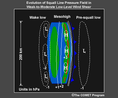

The surface pressure field during a squall line’s mature phase
reveals a pre-squall mesolow ahead of the system, a mesohigh collocated
with the surface cold pool, and sometimes a wake low at the back edge
of the stratiform precipitation.
The fields are similar whether the low-level wind shear is weak or strong,
but surface pressure gradients, and thus often the strength of the surface
winds, are usually stronger in stronger-shear environments.

As a squall line becomes asymmetric, the surface pressure field also becomes
distorted. Both the cold pool mesohigh and the trailing wake low are also
shifted northward.
3.2.7 Squall Line Evolution: Cross Section
View

Click the image above to view animation.
(Click the above image for animation, or see still series below:)
1 2
2 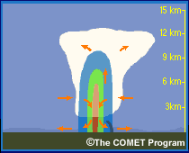
3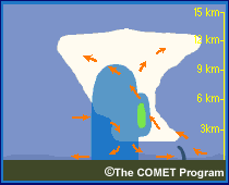 4
4 
5 6
6
7
This animation shows the idealized evolution of a typical squall line in
a vertical cross section with hypothetical radar echoes and cloud. Major
system updrafts and downdrafts are also shown. Note the repeated pulsing
of new cells along the leading edge of the system gust front with time and
then the movement of the cells rearward with time, which contributes to the
growth of the trailing stratiform precipitation. The gust front in this depiction
outruns the system, which is depicted in a storm-relative reference frame.
End of Section 3.2: Squall Lines - Evolution


 4
4 
 6
6
