3.1.1 What is a Squall Line?

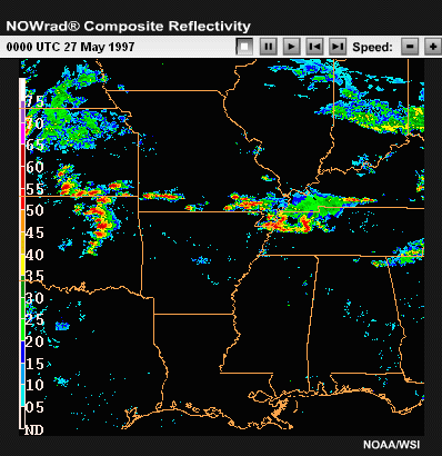
Click the image above to view animation.
Probably the most frequently observed form of mesoscale convective organization
is the squall line. A squall line may be thought of as any line of continuous
or nearly continuous convective cells. There is NO strict size definition
for squall lines, although for investigative purposes some authors have proposed
50 kilometers long, and 10 kilometers wide. A significant distinction from
other type of convective storms is that squall lines have a larger length-to-width
ratio. They are most commonly composed of mostly ordinary cells; however,
when the environment exhibits strong deep vertical wind shear, squall lines
may also initially be composed of primarily supercells, as is the case in
this radar loop. During the early stages of such systems, supercells may
exist along the entire extent of the line. However, over time the supercells
are often disrupted as their varying storm motions cause them to interact
with other nearby cells.
3.1.2 Supercell-Favored Locations

Click the image above to view animation.
Even for the strongest, most favorable shear profiles, supercell structures
within the center portion of a squall line usually evolve into more linear
convective structures like bow echoes. However, the cells at the ends of the
lines are more able to maintain their independence and can remain supercellular
for long periods of time. It is fairly common to find supercells only at the
southern end of mature, north-south oriented squall lines. It is also common
to find supercells at breaks within otherwise solid squall lines. Both of these
locations need to be monitored carefully for an increased potential of severe
weather.
3.1.3 Squall Line Classification

Squall lines form in a variety of ways. They often originate as a scattered
line of convective cells, with new cells eventually filling in the holes
in the line, but they also may be triggered as a nearly solid line to begin
with. As mentioned before, this latter scenario is especially likely when
there is a strong linear forcing mechanism present, as with a cold front
or dryline. In some cases, squall lines are also observed to form from more
scattered regions of convective cells or embedded within a more uniform region
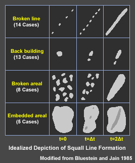
of stratiform precipitation. Bleustein and Jain’s study of the modes
of severe squall line formation in Oklahoma classified them into four categories: “broken
line,” “back building,” “broken areal,” and “embedded
areal,” with broken line and back building cases being the most common.
A 2003 study considering both satellite and radar observations of warm season
MCSs between the Rockies and the Appalachians determined that greater than
70% of the systems evolved from the merger of multiple convective clusters.
They also noted that MCSs that were linear at the time of formation resulted
in larger, longer-lived, more severe and effective precipitation producers
than those that formed from initially scattered storms. These results contain
useful operational information and are undoubtedly often related to the presence
of a stronger linear forcing mechanism for the more intense systems.
3.1.4 Review Question: Identify
Form of MCS
As you look at this next review question, recall the scenario at the start
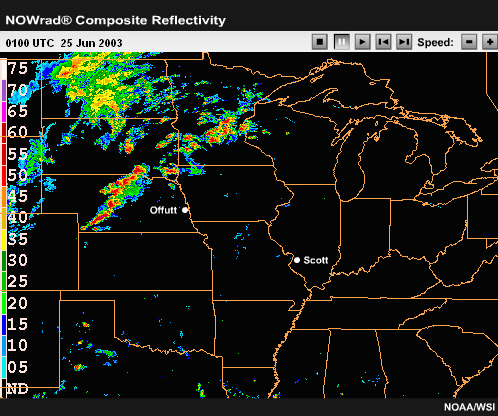
of this module. In the radar loop from 2100 UTC on 24 June through 0800
UTC on 25 June, Sergeant Slade observed the formation of a long squall
line over the Central Plains and upper Midwest.

Click the image above to view animation.
Basing your answer on the radar loop above, answer the following question:
What form or forms of MCS development do you see?
Please select all that apply:
a) Back building
b) Broken line
c) Broken areal
d)
Embedded areal
Review Question Feedback
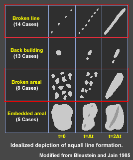
Expert Answer: The correct answers are b) Broken line and c) Broken areal.
Slade witnessed at least two types of formation in this developing system.
Cells from southwest Nebraska to southeast South Dakota became a broken line
that matured by 0100 UTC. There was evidence of an expanding cold pool from
the new cell development northwest of the line and an eastward-moving bulge
in the line. Broken areal formation is represented by the larger area of broken
cells and clusters from eastern South Dakota to extreme northwest Wisconsin.
It should be noted that this larger area of convection did not take on the
characteristics of a mature squall line until several hours later.


Click the image above to view animation.
End of Section 3.1: Squall Lines - Overview
