1.1 Set Up
Scott Air Force Base, 25 June 2003 0300 CDT (0800 UTC) on the mid-shift
that runs from midnight (0500 UTC) to 0800 CDT (1300 UTC).
Narrator: June 25th 2003 at 08Z on the mid-shift. Master
Sergeant Slade has the weather watch at Scott Air Force base in southern Illinois.

Master Sergeant Slade: Here I am…working another
mid-shift. Never liked ‘em…but that’s why I get the big
bucks. Just got back from Germany about four weeks ago and got recertified
to work the counter. This is where I started my career in Air Force Weather.
It’s good to be back. My name is Slade, Master Sergeant Jack Slade,
and I’m a meteorologist.

Click the image above to view animation.
It’s been perfect flying weather for the past few days. We’ve
been under the influence of an extensive high-pressure region with the upper-level
ridge. It looks like that’s about to change though as we come under the
influence of the upper trough to the west. We’ll have to watch this closely.
We’ve got flight operations planned for today beginning at 15Zincluding
an important flight from Scott to Offutt…and a lot of local flying as
well.
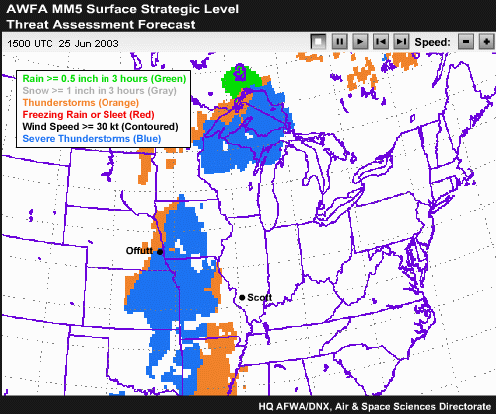
Click the image above to view animation.
Just looking at the threat assessment progs from the MM5, there’s
a threat of severe weather impacting air travel between Scott and Offutt.
I can see an indication of thunderstorms, including severe levels in blue
from Offutt to the western side of Illinois. It looks like this’ll extend
from at least 15Z to 00Z this evening. I’ll be getting a call for an
update from the duty officer any minute so I’d better take a closer
look at this.
1.2 Composite Chart (08Z)
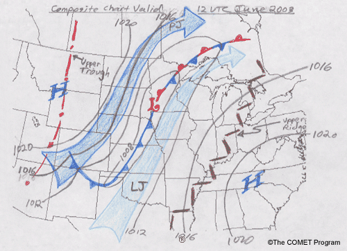
My predecessor left me a synoptic scale composite chart valid at 12Z. It
looks like a rotated version of a Johns classic warm season severe weather
pattern. It’s looking like the ingredients are in place for an area
of long-lived convection centered over Iowa.
(Compare above chart to the Johns classic warm-season severe weather pattern
below.)

1.3 A Closer Look

Click the image above to view animation.
The gridded forecast surface winds from the 45 kilometer version of the
MM5 certainly show the dramatic shift across the cold front. I see the surface
low pulling out of southeast South Dakota toward northern Minnesota over
the next 12 hours. The forecast wind speeds seem to be pretty reasonable
compared to the current observations.
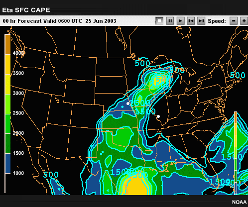
Click the image above to view animation.
I like to consult data from several models whenever possible. So, checking
the CAPE forecast loop from the Eta model I can sure see why the MM5 is showing
the high severe weather threat over southern Iowa and northern Missouri.
The CAPE values over the flight route between Scott and Offutt are progged
to be 1500 to 2500 J/kg throughout the day.

Click the image above to view animation.
In fact, the current composite radar loop shows that intense storms developed
out in Western Nebraska before 00Z. And now, there’s a pretty good
squall line from southern Nebraska to northern Wisconsin. Overall, this
is a pretty extensive MCS (mesoscale convective system) with precipitation
stretching clear up to Canada. Everything seems to indicate a good chance
for severe convection over Iowa with that system coming in from the northwest.
Of course the question is, will it hold together? The central portion of
the squall line moving into northwest Iowa is weakening right now, so I’m
not sure.
1.4 Confidence Check (08Z)

Still, the model sounding for Offutt from the MM5 valid at 06Z shows a
small cap and a lot of buoyancy…slightly
more than the Eta does. The wind profile and the hodograph look good. Substituting
the actual 06Z surface wind observation of 160 degrees at 15 knots, the low-level
shear exceeds 40 knots. This
is in the moderate-to-strong range. That amount of shear ought to allow for
continuation, if not intensification, of the squall line that’s already
in place.

Click the image above to view animation.
Over the last 12 hours, there were several reports of severe weather extending
from Southwest Nebraska to the southwest corner of Minnesota indicating tornadoes,
large hail, and wind damage. Based on what I’ve seen so far, there’s
good reason to be concerned about continued thunderstorms over Iowa along the
flight route between Scott and Offutt.
1.5 Call From Colonel Johnson (1215Z /0715
AM CDT)

(Sound: RING!)
Slade: Base weather station, Master Sergeant Slade, duty
forecaster. May I help you?

Colonel Johnson: This is Col. Johnson. How’s it going,
Jack? You might have heard, we’ve got a couple of C-130s headed for
Offutt this morning…for the air show. They’re set for takeoff
at 15Z and they’ll be cruising at 10,000 feet.

I’m a little concerned about severe weather en route. They can’t
exactly fly over it since they’re unpressurized. So Jack, how’s
it look between here and Offutt? And how does it look for local flying this
afternoon?
Slade: I was just checking my most current charts, Sir.
May I call you right back?

Click the image above to view animation.
(Slade reviews new data.)
Looking at the recent radar composite loop and surface obs, I can see
that Offutt should be in the clear by 15Z. On the other hand, storms are
firing in northwest Iowa big time. There’s a small line-echo wave
pattern and quite a few storms breaking out in advance of the main stuff…no
wonder, the dewpoints in Iowa are in the 70s! The good news is it looks
like we’re
all clear at Scott for the next 8 hours or so. Man, I wish the next model
runs were in!

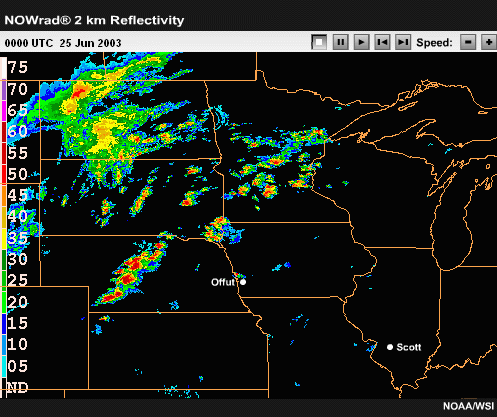
Click the image above to view animation.
To get a better handle on the timing, I compared the Eta convective precip
forecast from the 00Z run, valid for the 12-hour period ending at 12Z,
with the current radar. Looking closely, I see that the extent and pattern
with this system has been pretty darn good for the past 12 hours. The model
didn’t
pick up on precipitation in North Dakota, northern Minnesota, or the early
stuff in the extreme northwest corner of Kansas. It did really well, though,
for the main squall line from Nebraska to southern Minnesota.
(Slade calls Col. Johnson.)
Slade: Col. Johnson?

Col. Johnson: This is the Colonel.
Slade: Slade here. Sorry for the delay. The weather at
both Scott and Offutt looks really good this morning, but I think the flight
from Scott to Offutt may encounter severe weather after 15Z.
Col. Johnson: I see…
Slade: I’m expecting widespread severe weather with
a line of thunderstorms from a system currently in northwest Iowa. Some of
the embedded cells have been producing severe conditions. I expect the line
of convective storms to move in to the area of Scott by this evening. We’ll
be keeping a close eye on this system today.
Col. Johnson: I see.
Slade: How about if I have my relief, Tech Sergeant Simpson,
call you after 18Z with an update, Sir? She’ll have the most current
model data then.
Col. Johnson: Okay, tell her to keep
me posted.
Slade: Yes Sir.
Slade: At 13Z, my relief, Tech Sergeant Melanie Simpson
showed up. I briefed her on the current weather situation and brought her
up to date on the flight schedule for the day. I’m outta here.
(Slade signs off)
1.6 Simpson Analyzes New Data
(14Z)
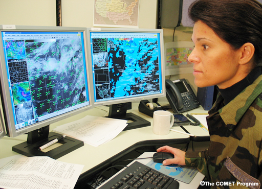
Technical Sergeant Melanie Simpson: Tech Sergeant Melanie Simpson here.
It’s
14Z now, the sun’s
been up for awhile and I’ve got the first few visible satellite images
of the day.
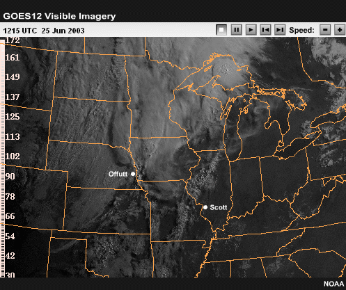
Click the image above to view animation.
The deep convective tops in Iowa stand out and I see some Cu here
at Scott. There’s also an interesting rope-like feature stretching
along the front in central Kansas. And it looks like plenty of heating
should occur today ahead of the existing storms.

Click the image above to view animation.
I’ve also got the 12Z model data now. The MM5 run seems to match
well with the obs. The position of the front at 12Z is right on. On the
other hand, I see that the actual temps in central Iowa and northern Missouri
haven’t
made it to 80 yet—the model forecasts indicate they should have. I really
want to look at some sounding data.
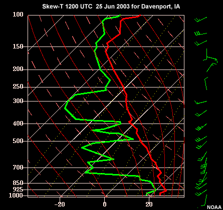

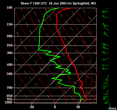
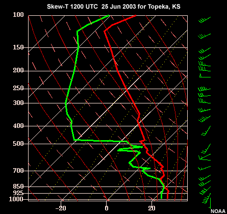
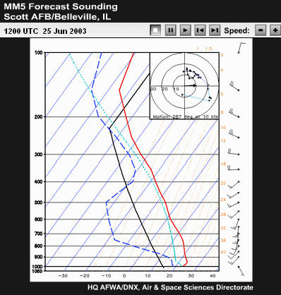
Click the image above to view animation.
I’m gonna start by looking at four upper-air sites that lie between
us and the current position of the squall line. I selected Davenport, Iowa
to our north-northwest since it’s the closest to the main squall line
that’s been working its way eastward. The morning sounding is indicating
good low-level moisture…and some dry air aloft, so there’s lots
of high potential for creating strong downdrafts and wind damage. Lincoln,
Illinois is about 90 miles to the north.
I can see from their sounding that both moisture and heating are currently
lacking. So we’re probably in good shape here at Scott, at least for
a while.
Still, I’m a bit concerned that with the cold front to the west…and
the cloud development I saw along it, this line may fill in to the south.
Topeka, Kansas
is just downstream and their skew-T shows some strong instability…and
very good low-level shear as well.
Finally, I’ll take a peek at Springfield, Missouri. This site is
the farthest south and shows the best deep moisture. It wouldn’t take
much to initiate storms in that air mass! Unfortunately, we don’t have
an upper-air site here at Scott. However, I can look at the model grid point
forecast profiles for our location for the rest of the day, and compare it
to these observed soundings. At 12Z, our sounding profile looks pretty similar
to nearby Lincoln. After that, it shows us destabilizing and the low-level
shear maximizing at about 21Z. Looks like storms are in the forecast!
1.7 Product Check (1815Z/1315 CDT)
Okay…now I want to check out a few more products before I call the
Colonel with an update.

Click the image above to view animation.
Looking at the latest radar composite loop at 18Z, I see a bit of a break
in the middle of the line. But new convection is starting to fire in northwest
Missouri…and Topeka is right smack in the middle of it now. Looks
like a line of new storms is developing right along the actual cold front
farther to the west.
The general cell motion is to the northeast, but the system as a whole continues
to move eastward. From the 18Z surface data overlay, I can see that ahead
of the whole mesoscale convective system, temperatures are generally in the
low 90s and dewpoints are in the 70s. Obviously, this region is quite unstable.
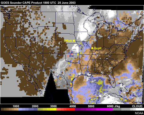
Before I call the Colonel, I also want to check out the new products from
the GOES satellite sounder. This CAPE product indicates over 2000 J/kg over
central Missouri and over 1000 in the area just west of Scott.
Looks like there is indeed plenty of fuel ahead of the existing squall line.
I don’t see it dying down any time soon. I guess it’s time to call
the Colonel.
1.8 Call to the Colonel (1830Z/1330
CDT)
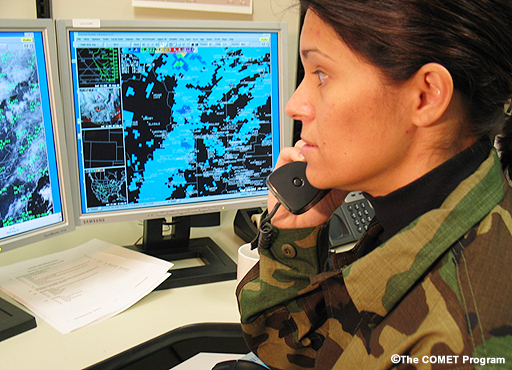
Simpson: Hello, this is Tech Sergeant Simpson from Weather,
Sir.

Col. Johnson: Hi Simpson. As Sergeant Slade indicated this
morning, we’ve got good weather at both Scott and Offutt for the time
being, but we’re still holding up that flight from Scott to Offutt.
How’s it looking for this afternoon?

Simpson: Well Sir, I’ve just
finished looking over the situation, and it doesn’t look good. Right
now we’ve got thunderstorms stretching from northern Oklahoma to central
Wisconsin. This system has produced large hail and 65 knot damaging winds
in the last couple of hours…and I’ve got every reason to believe
it will continue.

In fact, I expect the system to reach Scott by evening. We’ll be putting
out a thunderstorm watch for the base here shortly.
Col. Johnson: We’ll probably cancel then. Keep me
posted.
(Sound: Click!)
1.9 Review of 25 June (26 June 0030Z /1900
CDT)
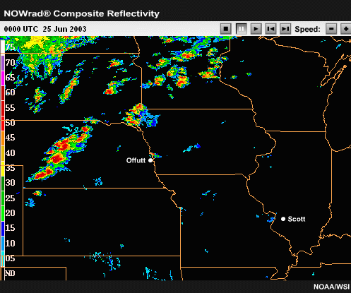
Click the image above to view animation.
Slade: Slade here. I’m back on shift and things
are about to get exciting at Scott! The storms are just west of us now, and
there’s
also a new line forming to our west. This MCS looks pretty classic, with
strong storms at the leading edge…some of which are bowing…and
there’s
extensive stratiform precip behind.

They suspended operations at Scott a couple of hours ago…after we
issued the severe weather watch for the base. I heard we never did get to
launch the flight to Offutt. Here at Scott they got to fly in the first part
of the day at least.
Melanie told me that Offutt’s local weather was good after 15Z…when
that initial severe weather passed to the southeast. But Iowa and Northern
Missouri were clobbered by a huge MCS. So far, there’ve been no tornado
reports like yesterday. But lots of wind damage…and they got some
large hail between here and Offutt during the afternoon. The pilots at Scott
will be glad to ride out the storms this evening with their planes safe in
the hangers.

1.10 Case Summary
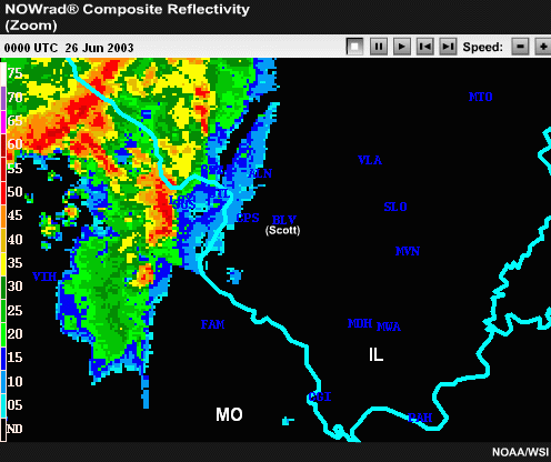
Click the image above to view animation.
Narrator: Slade and Simpson were right on track. The MCS
remained strong as it moved into Illinois that evening. It took on a bow shape
when it moved through Scott Air Force Base at around 03Z, or 10 PM local time.

Very heavy rains, lightning, and strong winds would have endangered any ground
operations or aircraft not parked in hangars. Anyone airborne would have encountered
severe turbulence or wind shear. It was a good thing that Simpson issued a
thunderstorm watch for the base.
End of Section 1: Scenario


