| Science 123 | Spring 2020 | |
Baroclinic Instability |
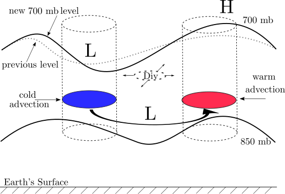
When the flow around a low center or trough becomes baroclinic (velocity vectors cross temperature contours) the resulting warm and cold advection regions in the downstream and upstream columns, respectively, cause the downstream column to expand and the upstream column to contract in the vertical direction. The warming and cooling of these columns cause the heights of the upper pressure surface to rise and fall, respectively. Consequently, the trough and ridge pattern at the upper level is amplified.
The "digging" of the upper level trough enhances the curvature vorticity in the upper air height contour pattern. When parcels pass through, and downstream from, this enhanced vorticity maximum, they move into a region of enhance divergence (as vorticity decreases, divergence increases). If the region of divergence is situated over the low at 850 mb, the low will deepen.
The increased pressure gradient associated with the low will cause an increase in the speed of the winds rotating counter-clockwise around the 850 mb trough of low center. As a result, the warm and cold temperature advection is increased which will further enhance the trough - ridge pattern above. This is an example of a "positive feed-back loop." Baroclinic instabilities often result in quickly strengthening storms because of these favorable, repetitive chain of events in the loop.
The parcels in the warm advection region also experience rising motion. These parcels generally originate near the Gulf of Mexico, so they likely have sufficient mixing ratios to create cloudy skies and areas of precipitation as they rise through the atmosphere experiencing a decrease in pressure, expansion and cooling. The change of phase (vapor to liquid and liquid to ice) releases latent heat that may significantly warm the column more, creating additional amplification of the upper level wave pattern. These phenomena are often associated with an advancing warm front at the surface of the earth.